info@penzionbaskavoda.cz +420732487862
BAŠKA VODA CZ
Unique family apartments in the foothills of the Beskydy Mountains
Nearby attractions - year-round
"Discover the best of our surroundings!"
We have prepared for you an overview of the most interesting places worth visiting during your stay with us.
Be inspired by our range of attractions and explore the beauties that await you near our guesthouse.
_-_view_from_Fr%C3%BDdlant_nad_Ostravic%C3%AD_edited.png)
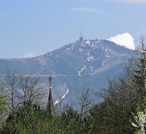
Lysa hora
Lysá hora ( German: Kahlberg; 1324 m above sea level , is the highest mountain in the Moravian-Silesian Beskydy and Těšín Region . It lies on the border of the municipalities of Krásná , Malenovice , Ostravice and Staré Hamry . This peak was also the highest point of the Protectorate of Bohemia and Moravia in 1939–1945 (although it is located in Silesia). On the bare (bald) peak, to which the road leads from Krásná, there is a characteristic telecommunications transmitter , a meteorological station and several mountain huts .
Several nature reserves and monuments have been created in the Lysá hora massif: Mazák and Mazácký Grúnik , Malenovický kotel , Satiny Waterfalls , Ostravice Riverbed , Ondrášovy díry ( Laščian: Ondrašovy ďury) and other smaller ones on the edges of the massif. The reason for the protection is the spruce forests with an admixture of fir-beech stands and areas of slope landslides. In the so-called Ondrašovy ďury there are pseudokarst caves and cracks that are also abundant in other parts of the mountain. Smaller rock formations have been created in the area of the Mazák and Řehucí streams, and waterfalls are characteristic of the Satin stream. The Ostravice Riverbed is protected due to its geological quality. The peak of Lysá hora was seriously damaged by industrial logging in the past.

Pustevny
Pustevny (1018 m above sea level ) is a saddle in the Moravian-Silesian Beskydy Mountains near Radhoště , which belongs to the municipality of Prostřední Bečva ( Vsetín district ). It was named after the hermits who lived here until 1874. Pustevny is characterized by wooden buildings built in the folk style at the end of the 19th century to the design of the architect Dušan Jurkovič . There is a ski resort here and a chairlift leads here. Under the peak of Tanečnice, the panoramic Valašska Trail was opened in 2019 .
The most famous buildings in Pustevny are Libušín and Maměnka . Both were built in 1898 thanks to the efforts of the tourist association Pohorské jednota Radhošť. They are wooden log cabin Art Nouveau buildings with rich decor typical of Wallachia and Slavic folk architecture in general.
In Pustevny there are also Zvonička Pustevny, Koliba U Záryša , Chata Šumná , Koliba Valaška , Chata na Pustevny and Hotel Tanečnica . From Pustevny a path leads along the ridge towards the west past the statue of the pagan god Radegast from 1931 to the top of Radhoště . Here there is a chapel from 1898 and a sculpture of Cyril and Methodius from 1930. On the way there is a wooden gazebo from 1928.

Radhost
Radhošť ( Moravian: Radhošč) is a mountain in the Moravian-Silesian Beskydy Mountains at the end of the prominent Pustevenský Ridge , 3 km southwest of Trojanovice and 6 km northeast of Rožnov pod Radhoštěm . With an altitude of 1,129 m above sea level, it is the seventh highest mountain in the Moravian-Silesian Beskydy Mountains and their westernmost thousand-meter peak .
According to legend, the Slavic god Radegast (Radhošť) - the God of the sun, war and victory - has been based on Radhošt since ancient times. His appearance, as depicted in the statue by Albín Polášek , does not seem particularly pleasant and angering him would probably not be good for a person. Despite this, or perhaps precisely because of this, generations of people have loved and cursed Radegast. Our ancestors respected him.
Nowadays, pilgrimages to Radhošť are held regularly in the summer, always attended by several thousand pilgrims. In 1939, at the beginning of the Nazi occupation, there were about 50,000 pilgrims on the pilgrimage to Radhošť.
Stramberk
Štramberk ( German : Strahlenberg or Stramberg) is a town in Nový Jičín District in the Moravian-Silesian Region , near Kopřivnice . It lies on the slopes of Zámecký kopec, Kotouč and Bílá hora in the Libotín Hills in the foothills of the Beskydy Mountains .
The dominant feature of the city is Štramberk Castle with the Gothic Trúba Tower, 40 meters high and 9 meters in diameter, which has been used as a lookout tower since 1903. The area under the castle was elevated to a town in 1359 by the Moravian Margrave Jan Jindřich . The town square houses the Štramberk Museum and the Zdeněk Burian Museum. The local city monument reserve protects not only the city core itself, but especially the historical wooden buildings on the outskirts. On Kotouč Mountain, there is the city park Národní sad with a gallery of sculptures and monuments to figures of Czech history and the Šipka Cave , which became famous for the discovery of a fragment of the lower jaw of a Neanderthal child, the so-called Šipecká jaw .
When visiting, don't forget to buy the popular local gingerbread confectionery, the so-called Štramberk ears!
_-_general_view_of_the_town_edited.jpg)

Hukvaldy
The village of Hukvaldy (German: Hochwald) is located in the Frýdek-Místek district of the Moravian-Silesian Region, in the foothills of the Moravian-Silesian Beskydy Mountains. It consists of five parts: Hukvaldy, Horní Sklenov, Dolní Sklenov, Rychaltice and Krnalovice.
Hukvaldy is the last purely Laščian village in the center of Laščiai, and is dominated by the third largest castle ruins in the Czech Republic. The local game reserve, founded in the 16th century, is said to have inspired the composer and Hukvaldy native Leoš Janáček to write his opera The Tale of the Cunning Fox.
In the village of Hukvaldy itself, you can find more than twenty-five sights, from the aforementioned castle ruins, a windmill to the Leoš Janáček monument. The village also hosts many cultural events, starting with the Leoš Janáček International Music Festival, then the International Festival of Advent and Christmas Customs, Carols and Crafts, as well as the Kryštof Camp or the Rock Bike Fest.

Roznov pod Radhostem
Rožnov pod Radhoštěm (until 1912 only Rožnov, German Rosenau or Rožnau) is a town with a total area of 3,948.23 ha with a range of elevations of approximately 360–950 m above sea level, most of the area in the landscape area is formed by the Rožnov Ridge, part of the Western Beskydy Mountains.
The Wallachian Open Air Museum in Rožnov pod Radhoštěm is part of the National Open Air Museum in the Czech Republic, organizes a collection of immovable and movable documents on the history of folk culture, manages collection items of an ethnographic nature and objects of folk architecture and technical construction located in the natural landscape, documents the folk culture of the ethnographic region of Wallachia, Cěšín Silesia and keeps genealogical records of families from the Moravian Wallachia region.
Specialized exhibitions include the Wooden Town, one of the oldest in Central Europe (established in 1925), the Wallachian Village, the largest area of a stylish village with animal husbandry and a presentation of farming and crop cultivation methods (the so-called living museum), and the Mill Valley.

Bumbálka
Bumbálka (altitude 870 m) is a mountain saddle in the main ridge of the Turzovská vrchovina, between the Beskydok (953.1 m) and Beskydy (900.1 m) hills in the Moravian-Silesian Region, on the Czech-Slovak border.
South of the saddle, the Trojačka stream, the source of the Kysuce, originates in Slovak territory. The main European watershed runs through the saddle.
The area around the saddle is currently a recreational area on both sides of the border. The red-marked tourist route from the Makovský Pass along the ridge further northeast also runs through the saddle, the yellow-marked route leads from the settlement of Trojačka to the Salajka National Nature Reserve on the Moravian side. The main ridge is also followed by a ski tourist route, and an educational trail connects Bumbálka with the Makovský Pass lying further south.
Near Bumbálka is the point in the Czech Republic that is farthest from the sea. A kind of Czech pole of relative inaccessibility.

Frenstat pod Radhostem
Frenštát pod Radhoštěm (Silesian: Frenštat, German: Frankstadt) is a town in the Nový Jičín District in the Moravian-Silesian Region. It lies amidst the picturesque landscape of the Moravian-Silesian Beskydy Mountains, between the confluence of the Lubina and Lomná rivers. It is the gateway to the Beskydy Protected Landscape Area and a center for mountain tourism and winter sports. Its historic core has been an urban conservation area since 2003.
The town of Frenštát is a popular cultural and sports center. The most famous events include the annual Martinský trh (St. Martin's Market) and its associated celebrations around November 11th, the Goulash Festival (goulash cooking competitions and the best goulash competition combined with a rich cultural program) and many other events.
The Horečky ski jumping area has four ski jumping hills in operation: K95, K45, K20 and K9, all of which have undergone reconstruction, including modernization of profiles and laying of new Finnish material. Aquapark Frenštát pod Radhoštěm was opened in 2001. The pride of the area with an area of 1049 square meters is a large swimming and multi-purpose pool with many water attractions. It is known for its 5.8-meter high and 60-meter long water slide and 13.1-meter high slide. The total volume of water in both pools reaches 1437 cubic meters.
Since 2010, the city has been hosting an extreme mountain ultramarathon race called the Beskydy Seven.

Żywiec
Żywiec (German: Saybusch, Czech: Živec, Yiddish: Żivitz) is a town in southern Poland, in the Silesian Voivodeship, 15 km south of Bielsko-Biała. It is the capital of Żywiec County. It is located in the Żywiec Basin at the confluence of the Koszarawa and Soła rivers. It has a population of approximately 30,000. The first mention of the location dates back to 1308, and city rights from 1327.
The Old Żywiec Castle is a historic building in the center of Żywiec, built around the 15th century. In 1477, when the loyalty of the city and its owners to the Polish crown was uncertain, Żywiec was conquered for the second time by the royal army and the castle was razed to the ground. The new construction probably took place between 1485 and 1500, when two new northern towers were built and the southern towers were strengthened. Everything had a defensive and representative character with distinct Renaissance features. Around 1569, another reconstruction continued, when an arcaded Renaissance courtyard was also built and modifications were made with the intention of strengthening the palace's representative function, including the removal of the southeastern tower. The castle houses the City Museum.
The bell tower in Żywc is located in the corner of the square (Rynek) at the co-cathedral church of the Nativity of the Virgin Mary (Konkatedra Narodzenia Najświętszej Maryi Panny w Żywcu). The brick stone bell tower dates from 1724 and was built on the site of an older wooden bell tower from 1582, which was built by the Komorowski family and which burned down during the great city fire in 1721.